High-resolution sensors
High-resolution monitoring technique using multi-parameter sensors has revolutionised our physical understanding across spatial and temporal scales. The implementation of optical high-frequency sensors in different water bodies allowed for timely observation of water quantity and quality at sub-hourly time scales, which are relevant for complex processes disentangling and guiding efficient management practices. The high-resolution technique was traditionally perceived as an expensive and scientifically-driven monitoring approach. However, under rapidly changing climate conditions and their associated impacts on water availability and quality, decision-makers started widely implementing this technique as an accurate, near-time, automatic and detailed monitoring approach, improving their management capability. The Bode River basin, with its largest drinking water reservoir in Germany, is one of the most monitored river basin systems (reservoir and catchment) in central Europe, with more than 12 years of high-resolution monitoring data. The Bode River basin will serve as a benchmark and showcase for the rest of the demo sites for designing and optimizing their high-resolution strategies. The continuously gathered data and information from multiple sources, including sensors, remote sensing, and modeling results, will be integrated into the digital twin systems of each demo site and will allow for equitable water distribution and management at the catchment scale, targeting multi-sectoral benefits, including domestic use, food production, and ecosystem needs.
Employing optical cameras for quantifying turbidity
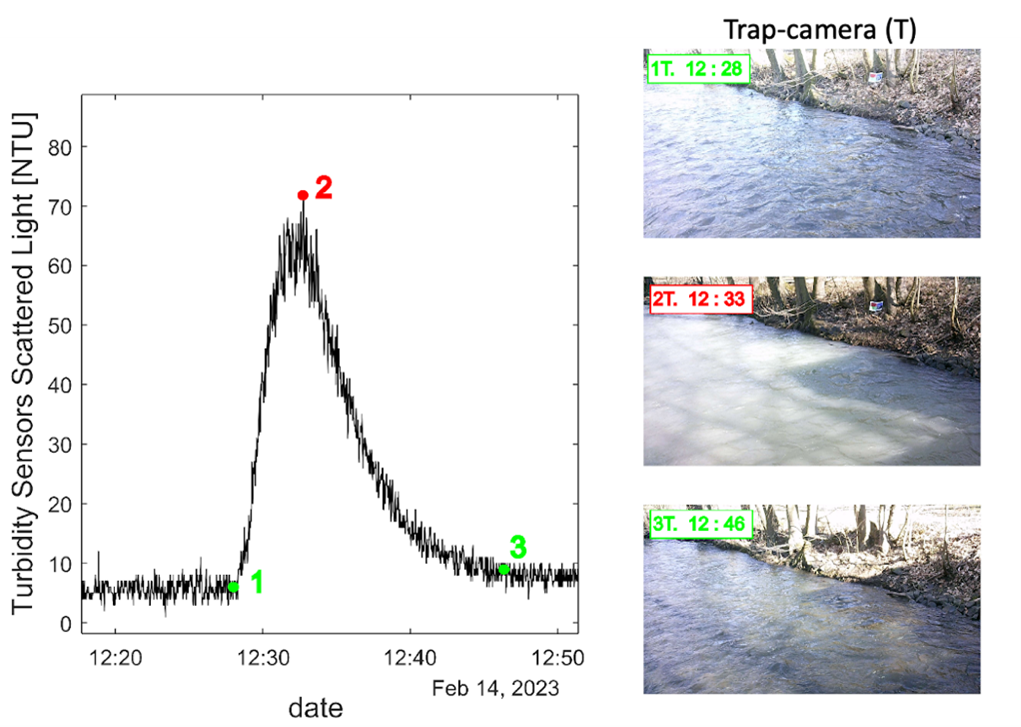
The detection of turbidity plays a pivotal role in assessing water quality and is of paramount importance for protecting the environment and aquatic ecosystems. Turbidity serves as a relative gauge for various physical attributes, including suspended sediment concentration (SSC), total suspended solids (TSS), and the presence of diverse compounds in water. Its close association with these variables makes turbidity a commonly used method for quantitative assessment. Fluctuations in turbidity can be influenced by seasonal variations and precipitation events, while elevated turbidity levels can result from the proliferation of algae and other organisms during the summer (Manfreda et al., 2023).

Example of a flood event with a rapid chance in turbidity with associated camera shooting
MEDWaterHub
OurMED will develop a sustainable knowledge hub “MEDWaterHub” for water-related ecosystems in the entire Mediterranean Region, that helps countries in their monitoring, decision-making, and reporting obligations under different global regional and national agreements conventions, and strategies (i.e. SDGs, Ramsar, CBD, EU Water Directives Barcelona Convention and National Strategies related to biodiversity, wetlands and water resources).
River Basin Digital Twins
River Basin Digital Twins (RBDTs) aim to provide a virtual representation of the physical river basin to gain control of the system. RBDTs should connect not only physical, chemical, and biological elements but also incorporate socio-economic components of a water system. As a result, RBDTs are tailored specifically to the physical river basin they represent.
RBDTs allow for real-time data recording and enable predictions through the incorporation of numerical models. They facilitate the integration of a wide range of data sources, including real-time data, historical time-series, GIS products, Earth Observation (EO) data, and geolocated data. This data can be processed and used either for direct visualization on the platform or as input for simulating the system and predicting relevant variables. Real-time data empowers managers to maintain control of the system and make immediate decisions. Predictive data, likewise, enables the anticipation of potential risks within the system, allowing for proactive measures to minimize damage.
RBDTs serve as a valuable tool for assisting decision-makers in system management and stakeholders in general. Through a risk alert system, stakeholders can be informed about system vulnerabilities at present and future time, such as flood risk, low flow risk, drought risk, and low water quality risk, making the system more resilient against climatic uncertainty and global change.
OurMED will explore all financial mechanisms for sustainability and make them accessible and test the upscaling of Sebou Water Fund to other demo sites.
Sebou water fund
The Sebou Water Fund, the first of its kind in the Middle East and North Africa (MENA) region, is a sustainable financing mechanism based on payment for ecosystem services that makes possible the conservation of water resources, the restoration of biodiversity, and the preservation of socio-economic and cultural activities that depend on them.


